Tuesday, November 8, 2011

Coonoor Hill Station

Coonoor Tourism India
Coonoor is a town and a municipality in the Nilgiris district in the state of Tamil Nadu, India. It is known for its production of Nilgiri tea.

Coonoor is located at an altitude of 1,800 m above sea level, and is the second largest hill station in the Nilgiri hills. It is an ideal base for a number of trekking expeditions leading into the Nilgiris.

Coonoor is connected by a metre gauge railway line in the world famous Nilgiri Mountain Railway (NMR) between Mettupalayam (28 km) and Ooty (17 km).

The main attraction within the town is Sim's Park, a small well maintained botanical garden that has several varieties of plants. It is spread over 12 hectares. It is about 19 km on road to the south of Ooty and is accessible by both train and road. It also hosts an annual “Fruit Show” in summer.

Coonoor
There are trekking trails leading out from the town. One of the popular trekking trails leads Tourists to Lamb’s Rock that is 9 km from Coonoor. Lamb’s Rock overlooks the Coimbatore plains, providing a spectacular view of the tea and coffee plantations. A little ahead of Lamb’s Rock is located the Lady Canning’s Seat that offers a panoramic view of the Nilgiris.

Tourist can trek from Lady Canning’s Seat to Dolphin’s Seat, which is located 12 km from Coonoor. Nearby is Law’s Falls, which is located 5 km from Coonoor. It is possible to trek from the falls to Droog that is located at a distance of 13 km from Coonoor.Droog is also known as Pakkasuran Kottai. The ruins of a 16th century fort can be seen in Droog. The fort is located at a height of 750 m.

How to Reach Coonoor


By Air: The nearest airport is Coimbatore International Airport which has regular flights from Delhi, Kolkatta, Mumbai, Ahmedabad, Bangalore, Calicut, Chennai, Cochin, Hyderabad, Thiruvananthapuram, Jammu, Pune, New Delhi, Bangkok, Kuala Lumpur, Bahrain, Kuwait, Muscat, Sharjah, Abu Dhabi, Colombo, Dubai, Doha, Singapore etc.

By Rail: Mettupalayam is the nearest railhead, which is 46 km away. The major railway junction is at Coimbatore (80 km).

The Nilgiri Mountain Railway is one of the oldest mountain railways in India. The Nilgiri Mountain Railway was declared by the UNESCO as a World Heritage Site in July 2005. This railway links Coonoor to the town of Mettupalayam at the foot of the hills. The Nilagiri Passenger train provides a convenient connection to the Nilgiri Express train to the state capital, Chennai via Coimbatore. Coonoor was the original termination point of the NMR in the hills, before the line was extended to Ooty.

By Road: Coonoor is well-connected by road with Ooty, Coimbatore, Mysore and Bangalore. The road that connects with Ooty is the National Highway 67 is one of the busiest Nilgiri Ghat Roads, and is also one of the main access routes for the entire district. Alternatively, there is another route that links Coonoor to Kotagiri via Bandishola and Bettati Tollgate, this road connects with State Highway 15 (SH15) that leads to Kotagiri from Ooty.

There are regular buses from Ooty, Bangalore, Mysore, Coimbatore, Erode, Calicut, Kanyakumari, Thanjavur, Tirupati, Madurai, Trichy, Salem and Cochin.

Best Time to Visit Coonoor


The best time to visit Coonoor is April to June & September to November.

Coonoor Weather


Map of Coonoor


Map of Coonoor


Places to Visit in Coonoor


Sim's Park


sim's Park Coonoor


The Sim's Park is an important place to visit in Coonoor. Spread in an area of 12 ha, the park has a collection of over 1,000 plant species, including magnolia, pines, tree ferns, and camellia. The botanical garden is partly developed in the Japanese style and derived its name from J. D. Sim, the secretary of the Madras Club in 1874. The key attraction of the park is the annual fruit and vegetable show held in May.

Pomological Station


The institute is a research centre of the State Agricultural Department for persimmon, pomegranates, and apricot.

Dolphin's Nose Viewpoint


Dolphin's Nose Coonoor


The Dolphin's Nose Viewpoint is 10 km from Coonoor . It not only provides a panoramic view of the vast expanse of the Nilgiri Hills but also of Catherine Falls.

Lamb’s Rock


Lamb’s Rock Coonoor


On way to Dolphin's Nose, about 5½ km from Coonoor, lies Lamb's Rock, another vantage point to view the fantastic landscape and the tea and coffee plantations.

Droog


At a distance of 13 km from Coonoor, Droog takes one into the past, with the ruins of a fort, which was once used by Tipu Sultan in the 16th century.

Law's Falls


Law's Falls Coonoor


The majestic falls are 5 km from Coonoor, on the way to Mettupalayam.

Katary Falls


The main place of attraction is the power station which supplies a power of 1000KW of power near Selas.

Pasteur Institute


Pasteur Institute Coonoor


Tourists require a special permission to visit this institute. This institute is located near Sim’s park. It was started in 1907. This institute develops vaccination for rabies (dog bite disease) and Triple Vaccine (DPT, DT & TT).In earlier days, it plays a vital role in the research of Influenza vaccine. Now it produces Tissue Culture Anti Rabies Vaccine (TCARV) and DPT group of vaccines.

Hotels in Coonoor


Evans Holiday
The Gateway Hotel
Hill Worth Resorts
Velan Hotel Ritz
The Riga Residency
Adderley Guest House

Coonoor Photos


Coonoor Hill Station

Coonoor Hill Station

Coonoor Hill Station


Coonoor Hill Station


Coonoor Hill Station

Coonoor Hill Station

Coonoor Hill Station

Coonoor Hill Station

Coonoor Hill Station

Coonoor Hill Station

Coonoor Hill Station

Coonoor Hill Station

Coonoor Hill Station

Coonoor Hill Station

Coonoor Tourism | How to Reach Coonoor | Tourist Places in India | Coonoor Weather | Map of Coonoor | Places to Visit in Coonoor | Hotels in Coonoor | Coonoor Photos

Kodaikanal Hill Station


Kodaikanal Tourism
Kodaikanal is a city in the hills of the taluk division of the Dindigul district in the state of Tamil Nadu, India. Its name in the Tamil language means "The Gift of the Forest". Kodaikanal is referred as the "Princess of Hill stations" and has a long history as a retreat and popular tourist destination. It's a lot cooler in temperature than lower elevation cities such as Chennai.

Kodaikanal was established in 1845 as a refuge from the high temperatures and tropical diseases of the plains. Much of the local economy is based on the hospitality industry serving tourism.

Kodaikanal
The town of Kodaikanal sits on a plateau above the southern escarpment of the upper Palni Hills at 2,133 metres (6,998 ft), between the Parappar and Gundar Valleys. These hills form the eastward spur of the Western Ghats on the Western side of South India. It has an irregular basin as its heartland, the centre of which is now Kodaikanal Lake a 5 kilometres (3.1 mi) circumference manmade lake.

Kodaikanal
Meadows and grasslands cover the hillsides. Gigantic Eucalyptus trees and shola forests flourish in the valleys. Mighty rocks and cascading streams. rise up from the valleys. There are many high waterfalls and ubiquitous gardens and flower beds in bloom.

North of the town, high hills that slope down into the villages of Pallangi and Vilpatti stand guard. On the east the hill slopes less abruptly into the lower Palnis. A precipitous escarpment facing the Cumbum Valley is on the south. On the west is a plateau leading to Manjampatti Valley, Indira Gandhi National Park, the Anamalai Hills and the main body of the Western Ghats.

How to Reach Kodaikanal


By Air: The nearest airport from the Kodaikanal is Madurai airport. It is 120 km away from Kodaikanal. Another nearest airport is Coimbatore which is 180 km from Kodaikanal. Coimbatore is connected to the major cities of India. Taxies are available form here to reach Kodaikanal.

By Rail: The nearest Railway stations are Palani Railway Station - 64 km, Kodai Road Station - 80 km & Dindigul Railway Junction - 100 km.

By Road: Kodaikanal is well connected with Madurai, Coimbatore, Bangalore, Kochi and Chennai by road.

Best Time to Visit Kodaikanal


April To June and September To October is the best time to visit Kodaikanal.

Places to Visit in KodaiKanal


Kodaikanal Lake


Kodaikanal Lake


Kodaikanal Lake, also known as Kodai Lake is a manmade lake located in the Kodaikanal city in Dindigul district in Tamil Nadu, India. Sir Vere Hentry Levinge, the then Collector of Madurai, was instrumental in creating the lake in 1863, amidst the Kodaikanal town which was developed by the British and early missionaries from USA. The lake is said to be Kodaikanal's most popular geographic landmark and tourist attraction.

Over the years a boat club, boathouse and boat service (with Rowing Boats and Pedalling boats and a public ferry) for the public and tourists has become fully functional and is of aesthetic significance for tourism. Boat Pageant and Flower Shows are a regular feature in the summer season which attracts tourists.

Bryant Park


Bryant Park Kodaikanal


Just east of the lake and 500 metres (1,600 ft) from the bus stand, is a wonderfully maintained 20.5 acres (8.3 ha) botanical garden. The park was planned and built in 1908 by a forest officer from Madurai, H.D.Bryant, and named after him. With 325 species of trees, shrubs and cactuses, the park is a rainbow of stunning flowers during the peak season. A large section is dedicated to nearly 740 varieties of roses. There is a 1857 Eucalyptus tree and a Bodhi tree which adds a religious significance to the park. Ornamental plants are cultivated in a nursery for sale. The park organizes horticultural exhibits and flower shows every summer, to coincide with the peak season. Entrance fee to the park is nominal and it is open all year.

Coaker's Walk


Coakers Walk Kodaikanal


500 metres (1,600 ft) from the bus-stand, constructed by Lt.Coaker in 1872, is a 1-kilometre (3,300 ft) paved pedestrian path running along the edge of steep slopes on the southern side of Kodai. The walk, winding around Mount Nebo, starts in front of the Van Allen hospital, running parallel to the Van Allen Hospital Road and joins the main road beside St.Peter's Church, providing a stunning panoramic view of the plains. On a clear day one can view as far as Dolphin's Nose in the south, the valley of the Pambar River in the southeast, Periyakulam town and even the city of Madurai. A fascinating rare phenomenon called Brocken spectre can be witnessed, when a person can see his shadow on the clouds with a rainbow halo. This occurs when the sun is behind the viewer and clouds and mist are to the front. There is an observatory with a telescope halfway along the walk. Entrance fee to the walkway is nominal and it is open all year.

Bear Shola Falls


Bear Shola Falls KodaiKanal


3 kilometres (1.9 mi) from the bus-stand, is a tall waterfall in a Reserve forest. The final approach to this quiet area is a gently climbing foot-path.

Green Valley View


Green Valley View Kodaikanal


5.5 kilometres (3.4 mi) from the bus-stand and near the golf course, has an excellent panoramic view of the plains and a sheer drop of 1,500 metres (4,900 ft) overlooking the Vaigai Dam to the south. The stairway leading up to it is highly commercialized and lined with rows of shops to tempt tourists.

Pine forests


Pine Forests Kodaikanal


In 1906, with a view to growing valuable timber, Mr. Bryant started the Kodaikanal pine plantations in the south-west of Kodaikanal.

Shembaganur Museum of Natural History


6 kilometres (3.7 mi) from the bus-stand, founded in 1895, is open to the public (except Tuesdays) for viewing their outstanding taxidermy collection of more than 500 species of animals, birds and insects and a living collection of over 300 exotic orchid species. The museum is affiliated with Loyola College in Chennai and exhibits artifacts of the ancient Palaiyar tribes people whose descendants still live in these hills.

Kodaikanal Solar Observatory


The Kodaikanal Solar Observatory is an solar observatory owned and operated by Indian Institute of Astrophysics. It is located on the southern tip of the Palni Hills 4 km from Kodaikanal town, Dindigul district, Tamilnadu state, South India.

The Evershed effect was first detected at this observatory in January 1909. Solar data collected by the lab is the oldest continuous series of its kind in India. Precise observations of the equatorial electrojet are made here due to the unique geographic location of Kodaikanal.

Ionospheric soundings, geomagnetic, F region vertical drift and surface observations are made here regularly and summaries of the data obtained are sent to national IMD and global WMO GAW data centers.

They have a full time staff of two scientists and nineteen technicians.

Pillar Rocks


Pillar Rocks Kodaikanal


8 kilometres (5.0 mi) from the bus-stand, is a set of three giant rock pillars which stand 122 metres (400 ft) high. Managed by the Tamil Nadu Forest Department, The viewpoint can be crowded but is not commercialized. There is an excellent public garden adjacent to the viewpoint.

Guna caves


Made popular by the Tamil movie Guna, previously called Devil’s Kitchen, are deep bat-infested chambers between the three gigantic boulders that are the Pillar Rocks. The deep narrow ravines of the caves are now closed to public due to the tragic deaths of twelve youths there.[citation needed] These dangerous caves are highly protected now, and tourists can see sections of the cave system from afar.

Silver Cascade


Silver Cascade Kodaikanal


8 kilometres (5.0 mi) from Kodaikanal at a wide bend in the long and winding Laws Ghat Road, at altitude 1,800 metres (5,900 ft), is a 55-metre (180 ft) waterfall formed from the outflow of Kodaikanal Lake. The water quality is reportedly poor and not good enough for bathing. This impressive waterfall is a popular stop for first-time visitors. There are a few souvenir and fruit vendors and many monkeys here. There is also a smaller but more serene waterfall below the bridge which crosses the stream here.

Dolphin's Nose


Dolphins Nose Kodaikanal


8 kilometres (5.0 mi) from the bus stand, is flat rock projecting over a breathtaking chasm 6,600 metres (21,700 ft) deep. It is an undisturbed area 1 kilometre (0.62 mi) down a very steep rocky trail beginning soon after Pambar Bridge. Orange juice vendors along the trail offer a welcome rest stop. Beautiful views of steep rocky escarpments rising from the plains can be seen. The old village of Vellagavi can be reached through a rugged bridle path here. A short paved walkway leads from the road here to Pambar falls (which is also locally addressed as 'Liril Falls' after the famous Liril Soap Advertisement filming in 1985).

Kurinji Andavar Murugan temple


Kurinji Andavar Murugan Temple Kodaikanal


4 kilometres (2.5 mi) from the bus-stand, is famous for its Kurinji flower which blossoms in the area only once every 12 years. The deity here is called Sri Kurinji Easwaran, who is in fact Lord Murugan. This temple was built in 1936 by a European lady, who on coming to Celon, converted to Hinduism.She changed her name to Leelavathi and married Mr.Ponnambalam Ramanathan. She is also known as Lady Ramanathan. This temple was handed over to Arulmighu Dhandayuthapani Swamy Thiru Kovil, Palani by Mrs Devi Prasad Bhaskaran(also known as Padmini, niece and adopted daughter of Mr S Natesan Pillai, son in-law of Lady Ramanathan) and her husband Dr R. Bhaskaran.

Kodaikanal Weather


Map of Kodaikanal


Kodaikanal Map

Hotels in Kodaikanal


Valley View Inn
Hotel Kodai International
Hotel Mount View
Hill Country Holiday Resorts
Snooze Inn
Hotel Sivapriya
Apple Valley
Club Mahindra Coakers
Silver Castle Resort
Kodai Plaza Hotel
Jaya Hotel
Saliha International Hotel
Richwin Hotel

Kodaikanal Photos


Kodaikanal

Kodaikanal

Kodaikanal

Kodaikanal

Kodaikanal

Kodaikanal

Kodaikanal

Kodaikanal

Kodaikanal

Kodaikanal

Kodaikanal

Kodaikanal

Kodaikanal

Kodaikanal Tourism | How to Reach Kodaikanal | Best Time to Visit Kodaikanal | Places to Visit in KodaiKanal | Kodaikanal Weather | Map of Kodaikanal | Hotels in Kodaikanal | Kodaikanal Photos | Tourist Places in India


Coorg Hill Station


Coorg Tourism
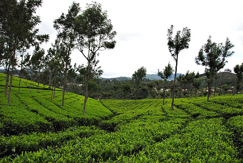
Kodagu is an administrative district in Karnataka State in southern India. It is also known by its anglicised former name of Coorg. It occupies an area of 4,102 square kilometres (1,584 sq mi) of land in the Western Ghats of southwestern Karnataka. As of 2001, the population was 548,561, with some 13.74% of the population residing in the district's urban centres.

Madikeri is the headquarters of the Kodagu district. The district is bordered by Dakshina Kannada district to the northwest, Hassan district to the north, Mysore district to the east, the Kannur District of Kerala to the southwest, and the Wayanad District of Kerala to the south.

Coorg Tourism
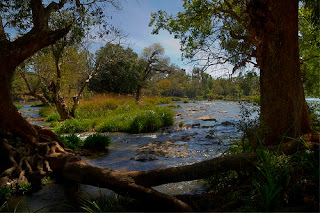
Kodagu is located on the eastern slopes of the Western Ghats. It has a geographical area of 4,102 km2 (1,584 sq mi). The district is bordered by Dakshina Kannada district to the northwest, Hassan district to the north, Mysore district to the east, the Kannur District of Kerala to the southwest, and the Wayanad District of Kerala to the south. It is a hilly district with the lowest elevation in the district at 900 metres (3,000 ft) above sea-level. The highest peak, Tadiandamol, rises to 1,750 metres (5,740 ft), with Pushpagiri, the second highest, at 1,715 metres (5,627 ft). The main river in Kodagu is the Kaveri (Cauvery). The Kaveri starts at Talakaveri, located on the eastern side of the Western Ghats, and with its tributaries, drains the greater part of Kodagu.

Coorg Tourism
In July and August, rainfall is intense, and there are often showers into November. Yearly rainfall may exceed 4,000 millimetres (160 in) in some areas. In dense jungle tracts, rainfall reaches 3,000 to 3,800 millimetres (120 to 150 in) and 1,500 to 2,500 millimetres (59 to 98 in) in the bamboo district to the west. Kodagu has an average temperature of 15 °C (59 °F), ranging from 11 to 28 °C (52 to 82 °F), with the highest temperatures occurring in April and May. The principal town, and district capital, is Madikeri, or Mercara, with a population of around 30,000. Other significant towns include Virajpet (Virarajendrapet), Kushalnagar, and Somwarpet. The district is divided into the three administrative talukas (divisions) of Madikeri, Virajpet and Somwarpet.

How to Reach Coorg


By Air: The nearest airport is Mysore Airport which is 120 KM away and Mangalore International Airport around 180 km away. Private taxies & buses are easily availble from here to reach Coorg.

By Rail: The nearest railway stations from Coorg are Thalassery, Mysore and Hassan.

By Road: Coorg is very well connected by road to the major cities of India.

Below are some important distance from Coorg:

Coorg to Mysore - 120 km
Coorg to Hassan - 115 km
Coorg to Mangalore - 135 km
Coorg to Bangalore - 250 km

Best Time to Visit Coorg


November to April is the best time to visit Coorg.

Map of Coorg


Coorg Weather


Places to visit in Coorg


Talakaveri


Talakaveri Coorg
Talacauvery, is the place that is generally considered to be the source of the Cauvery River. It is located in the Brahmagiri hill (not to be confused with the Brahmagiri range further South) near Bhagamandala in Kodagu district, Karnataka, 1,276 m. above sea level. However, there is not a permanent visible flow from this place to the main rivercourse except during the rainy season.

A tank or kundike has been erected on a hillside, at the place that is said to be the origin. It is also marked by a small temple, and the area is frequented by pilgrims. The Kaveri River originates as a spring feeding this tank, which is considered to be a holy place to bathe on special days. The waters are then said to flow underground to emerge as the river some distance away. The temple has been renovated extensively by the state government recently.

On Tulasankramana day (the first day of Tula Masa month, according to the Hindu calendar, which normally falls in mid October) thousands of pilgrims flock to the river's birthplace to witness the rise of the fountainhead, when water gushes up from the spring at a predetermined moment. The tula snanam (Sacred bath in the Tula month) is observed across pilgrim towns in Kaveri's banks.

Talacauvery is about 8 km away from Bhagamandala and 48 km from Madikeri.

Irupu Falls


Irupu Falls Coorg
The Irupu Falls (also Iruppu Falls) are located in the Brahmagiri Range in the Kodagu district of Karnataka, India, bordering the Wayanad district of Kerala. It is a fresh water cascade and is situated at a distance of 48 km from Virajpet on the highway to Nagarhole. The Falls are also known as the Lakshmana Tirtha Falls, derived from the name of the tributary of Cauvery which starts from these falls, the Lakshmana Tirtha River.

A forest trail leads from these falls to the Brahmagiri Peak in Southern Kodagu. Irupu falls is a major tourist attraction as well as a pilgrimage spot. A famous Siva temple, the Rameshwara Temple is situated on the banks of the Lakshmana Tirtha River, en route to the Falls. This temple attracts a large number of pilgrims during the festival of Shivaratri.

Abbey Falls


Abbey Falls Coorg
Abbey Falls (also spelled Abbi Falls and Abbe Falls) is in Kodagu, in the Western Ghats in Karnataka, India. It is located 8 km from the town of Madikeri and 268 km from Bangalore.

In the mountains of the Western Ghats, several streams combine, swelling with the monsoon rains and plunging down the mountain slope at enormous speed, hitting the huge boulders hard and forcing through the crevices and ravines. A misty cloud hangs over the falls. From here the water flows into the Kaveri River. During the monsoon season the water flow is very high. During the dry seasons the flow is considerably diminished.One can find a lot of leeches inside the water.

The waterfall is located between private coffee plantations with stocky coffee bushes and spice estates with trees entwined with pepper vines. The falls appear suddenly, the water cascading over rocks into calm pools. A hanging bridge constructed just opposite the falls comes in handy for the Tourists. There is a Kali Mata temple on the other side of the bridge and Coffee and Black Pepper trees on the other side.

Dubare


Dubare Coorg
Dubare is known for its elephant camp, and is a forest camp on the banks of the river Kaveri in the district of Kodagu, Karnataka. It is an important base for the Karnataka Forest Department's elephants.

The elephants for the Mysore Dussehra were trained at Dubare elephant camp. At present, after logging operations have ceased, the elephants have been practically retired except for giving some rides to tourists.

In addition to elephant training camp, Nisargadhama and Veerabhoomi are the other main attractions of the forest area.

There are opportunities for trekking, elephant rides, fishing, and river rafting. these activities are hosted by Jungle Lodges and resorts. The Forest Department also conducts some treks along well-defined routes.

The moist deciduous forests of Dubare are home to many wild animals and birds. Sighting of wild Asiatic elephants are regular and so is spotting the sambhar and the spotted deer. tiger, leopard, wild dogs, gaur and bears are also seen in these forests. Crocodiles can be seen in river. The forests are also home to many reptiles non-venomous snakes.

Birdlife in Dubare includes peacock, partridge, kingfisher and woodpeckers topping the list.

Dubare is easily accessible from Bangalore. The route from Bangalore is via Mysore, Kushalanagara, Gudde Hosur (4km from Kushalanagara on BM Road), then turn towards Siddapura. About 15 kilometer on the Siddapura Main Road visitors would find a Dubare Camp board.

Chiklihole Reservoir Dam


The unique thing about this dam is the scenic way in which water is allowed out of the reservoir.Roads are decent, but not wide enough for buses.

Nagarhole National Park


Nagarhole National Park Coorg
Nagarhole National Park, also known as "Rajiv Gandhi National Park", is located 94 kilometers (58 mi) from Mysore in Karnataka in South India. It is spread between Kodagu district and Mysore district. Located to the north-west of Bandipur National Park, Kabini reservoir separates the two. The park has rich forest cover, small streams, valleys, and waterfalls. The park has a healthy tiger-predator ratio, and tiger, Indian bison, and elephant are much more populous here than in Bandipur.

The park stretches over 643 square kilometres (248 sq mi), protecting the wildlife of Karnataka. Together with the adjoining Bandipur National Park (870 km2 (340 sq mi)), Mudumalai National Park (320 km2 (120 sq mi)) and Wayanad Wildlife Sanctuary (344 km2 (133 sq mi)), it forms the largest protected area in Southern India, totalling 2,183 km2 (843 sq mi).

The park is part of the Nilgiri Biosphere Reserve. The Western Ghats, Nilgiri Sub-Cluster (6,000+ km²), including all of Nagarhole National Park, is under consideration by the UNESCO World Heritage Committee for selection as a World Heritage Site.

Bhagamandala


Bhagamandala is a pilgrimage place in Kodagu, Karnataka, in India. It is situated on the river Kaveri in its upstream stretches. At this place, the Kaveri is joined by two tributaries, the Kannike and the mythical Sujyoti river. It is considered sacred as a river confluence (kudala or triveni sangama, in Kannada and Sanskrit respectively).

It is a common practice for pilgrims to take a dip in the triveni sangama and perform rituals to their ancestors before proceeding to Talakaveri, the birthplace of Kaveri. During Tula Sankramana which falls on October 17th or 18th, pilgrims assemble here in large numbers.

Dargah Sharief of Yemmemadu


Dargah Sharief, the Holy Tomb, of Yemmemadu is one of the most sacred shrines for Muslims in Kodagu district. (35 km from Madikeri; Madikeri-Bettageri-Napoklu-Hale Taluku-Yemmemadu)

Mandalapatti


28 km from Madikeri. On the way to Abbey Falls, before 3 km from Abbey Falls take right, from there 25 km.

Hotels in Coorg


Solitaire Exotica Resort
Hotel Hill View
Hotel Rajdarshan
Hotel Hilltown
Green Lines Stays
Hotel Heritage Resort
Orange County Resort
Green Hills Estate
Hotel Capitol Village Resort
Kannika International
Alpen Glow Homestay
Hotel Polaycad Estate
Hotel Kadkani Riverside Resorts

Coorg Photos


Coorg

Coorg

Coorg

Coorg

Coorg

Coorg

Coorg

Coorg

Coorg


Coorg

Coorg

Coorg Tourism India | How to Reach Coorg | Best Time to Visit Coorg | Map of Coorg | Coorg Weather | Places to visit in Coorg | Hotels in Coorg | Coorg Photos | Tourist Places in India